HAPPY HOLI Let HOLI make everything HOLY! Holi Festival also known as the festival of colours is a spring festival celebrated with much fervour in India and around the world. The festival signifies the victory of good over evil, the arrival of spring, end of winter, bringing in the air the fragrance of flowers and aura of warmth and happiness.
शुभ दीपावली Shubha Deepawali On this Deepawali/Diwali may the darkness go and may the inner divine light grow & glow, guiding you on the path of righteousness, virtue and dharma. On this auspicious occasion, let the fragrance & essence of pure love fill your life. Wishing you’ll a spiritually enriching celebration. दीपावली की हार्दिक शुभकामनाएं। Anu & Suchit Nanda https://photos.suchit.in/Other/Greetings/i-dFbxDwD/Aशुभ दीपावली Shubha Deepawali On this Deepawali/Diwali may the darkness go and may the inner divine light grow & glow, guiding you on the path of righteousness, virtue and dharma. On this auspicious occasion, let the fragrance & essence of pure love fill your life. Wishing you’ll a spiritually enriching celebration. दीपावली की हार्दिक शुभकामनाएं। Anu & Suchit Nanda https://photos.suchit.in/Other/Greetings/i-dFbxDwD/A
Wishing you and your family a Very Happy New Year filled with spiritual progress, inner journey, good health, prosperity, and all the happiness! From: Anu & Suchit https://photos.suchit.in/Other/Greetings/i-cQ3V6H9/A
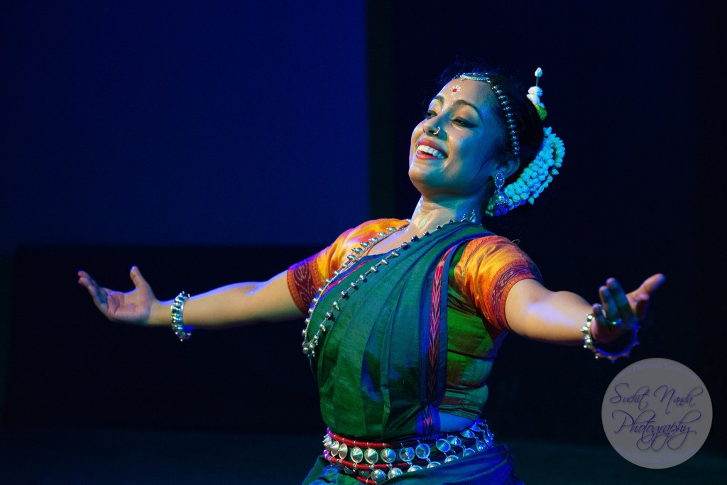
29th Raindrops Festival of Indian Classical Dance by Samved SFPA / Samved Society for Performing Society for Performing Arts & Uma Dogra. Friday, 12th July at SPJMIR, Bhavan’s Cultural Center, Mumbai, India. See the full set of high resolution images here: https://www.photonicyatra.com/Features/Festivals/29th-Raindrops-Festival-12Jul19
29th Raindrops Festival of Indian Classical Dance by Samved SFPA / Samved Society for Performing Society for Performing Arts & Uma Dogra. Friday, 12th July at SPJMIR, Bhavan’s Cultural Center, Mumbai, India.Eesha Pinglay (Bharatnatyam) dance performance at the 29th Raindrops Festival of Indian Classical Dance by Samved Sfpa (Samved Society for Performing Arts) & Uma Dogra. Friday, 12th July, 2019 at Bhavan’s Cultural Center, Andheri (W), Mumbai.Eesha Pinglay (Bharatnatyam) dance performance at the 29th Raindrops Festival of Indian Classical Dance by Samved Sfpa (Samved Society for Performing Arts) & Uma Dogra. Friday, 12th July, 2019 at Bhavan’s Cultural Center, Andheri (W), Mumbai.Rohini Banerjee (Odissi) performance at the 29th Raindrops Festival of Indian Classical Dance by Samved Sfpa (Samved Society for Performing Arts) & Uma Dogra- Friday, 12th July, 2019 at Bhavan’s Cultural Center, Andheri (W), Mumbai, India.Rohini Banerjee (Odissi) performance at the 29th Raindrops Festival of Indian Classical Dance by Samved Sfpa (Samved Society for Performing Arts) & Uma Dogra- Friday, 12th July, 2019 at Bhavan’s Cultural Center, Andheri (W), Mumbai, India.Ratheesh Babu & Sandhya Manoj (Kuchipudi and Odissi duet) performance at 29th Raindrops Festival of Indian Classical Dance by Samved Sfpa (Samved Society for Performing Arts) & Uma Dogra. On Friday, 12th July, 2019 at Bhavan’s Cultural Center, Andheri (W), Mumbai, India.Ratheesh Babu & Sandhya Manoj (Kuchipudi and Odissi duet) performance at 29th Raindrops Festival of Indian Classical Dance by Samved Sfpa (Samved Society for Performing Arts) & Uma Dogra. On Friday, 12th July, 2019 at Bhavan’s Cultural Center, Andheri (W), Mumbai, India.Prachi Save Saathi (Bharatnatyam) performance at the 29th Raindrops Festival of Indian Classical Dance by Samved Sfpa (Samved Society for Performing Arts) & Uma Dogra. Friday, 12th July, 2019 at Bhavan’s Cultural Center, Andheri (W), Mumbai, India.Prachi Save Saathi (Bharatnatyam) performance at the 29th Raindrops Festival of Indian Classical Dance by Samved Sfpa (Samved Society for Performing Arts) & Uma Dogra. Friday, 12th July, 2019 at Bhavan’s Cultural Center, Andheri (W), Mumbai, India.Megh Ayan Banerjee’s Kathak presentation at the 29th Raindrops Festival of Indian Classical Dance by Samved Sfpa (Samved Society for Performing Arts) & Uma Dogra. Friday, 12th July, 2019 at Bhavan’s Cultural Center, Andheri (W), Mumbai.Megh Ayan Banerjee’s Kathak presentation at the 29th Raindrops Festival of Indian Classical Dance by Samved Sfpa (Samved Society for Performing Arts) & Uma Dogra. Friday, 12th July, 2019 at Bhavan’s Cultural Center, Andheri (W), Mumbai.
Gangtok, Sikkim, India. Gangtok is located in the eastern Himalayan range, at an elevation of 1,650 m (5,410 ft). Gangtok rose to prominence as a popular Buddhist pilgrimage site after the construction of the Enchey Monastery in 1840. In 1894, the ruling Sikkimese Chogyal, Thutob Namgyal, transferred the capital to Gangtok. In the early 20th century, Gangtok became a major stopover on the trade route between Lhasa in Tibet and cities such as Kolkata (then Calcutta) in British India. Today, Gangtok is an emerging as urbanized city with literacy rate of 94% of total population.
Pakyong Airport(PYG), a Greenfield project near Gangtok, was commissioned in 2018. It is the first and only airport in Sikkim. The nearest railhead connected to the rest of India is the station of New Jalpaiguri(NJP) in Siliguri, situated 124 km (77 mi) via NH10 away from Gangtok.
Rumtek Monastery, located on the outskirts of Gangtokone, is one of Buddhism’s holiest monasteries.
Nathu La (Devanagari नाथू ला; Tibetan: རྣ་ཐོས་ལ་, IAST: Nāthū Lā, Chinese: 乃堆拉山口; pinyin: Nǎiduīlā Shānkǒu) is a mountain pass in the Himalayas in East Sikkim district. It connects the Indian state of Sikkim with China’s Tibet Autonomous Region. The pass, at 4,310 m (14,140 ft) above mean sea level and forms a part of an offshoot of the ancient Silk Road. Nathu means “listening ears” and La means “pass” in Tibetan. On the Indian side, the pass is 54 km (34 mi) east of Gangtok, the capital of Sikkim. Only citizens of India can visit the pass, and then only after obtaining a permit in Gangtok.
Night view at M.G. Mall Road, Arithang, Gangtok, Sikkim, North East India. Mahatma Gandhi Road or MG Road, is a street which is one of the focal point for tourists in Gangtok. Lined with shops both with branded items and with street-bargaining style shops.
Panoramic view of Kanchenjunga from Upper Pelling, Sikkim. North East India.Panoramic view of Kanchenjunga, Himalayan mountain range from Upper Pelling, Sikkim, North East India.Panoramic view of Kanchenjunga Himalayan mountain range, Pelling-Rimbi Rd, Pelling City, Sikkim, North East India.Tourists at Kanchandzanga Falls (कन्चंद्ज़ंगा फॉल्स), Pelling-Yaksam Road, Sikkim. North East India.Kanchandzanga Falls (कन्चंद्ज़ंगा फॉल्स), Pelling-Yaksam Road, Sikkim in North East India.Street portrait of Sikkim lady in traditional attire at monastery. Sanghak Choeling Monastery (संघक चोएलिंग मोनास्ट्री), Pelling City, Sikkim is a 17th-century Buddhist monastery in a remote area on a hill. North East India.Sky Walk Pelling Sikkim (स्काई वॉक पेल्लिंग सिक्किम) at the Sanghak Choeling Monastery (संघक चोएलिंग मोनास्ट्री), Pelling City, East Sikkim. North East India. This 17th-century Buddhist monastery on a hill has a great view of Kanchandzanga mountain.Buddhist golden prayer wheels at Sanghak Choeling Monastery (संघक चोएलिंग मोनास्ट्री), Pelling City, Sikkim, North East India. This 17th-century Buddhist monastery is located on a hill near Kanchandzanga mountain.Buddhist golden prayer wheels with a great view of Kanchandzanga mountain from Sanghak Choeling Monastery (संघक चोएलिंग मोनास्ट्री), Pelling City, Sikkim. North East India.Entrance to Pemayangtse Monastery (पेमयांग्त्से मोनास्ट्री), Geyzing, Sikkim, North East India. Multi-level historic buddhist monastery built in the 17th century and featuring a number of traditional statues, sculptures & paintings.Pemayangtse Monastery (पेमयांग्त्से मोनास्ट्री), Geyzing, Sikkim. Multi-level historic buddhist monastery built in the 17th century and featuring a number of traditional statues, sculptures & paintings. North East India.Panoramic view of Karma Shri Nalanda Institute (करमा श्री नालंदा इंस्टिट्यूट), Dharma Chakra Centre, Rumtek, Sikkim, North East India.Rumtek Dharma Chakra Centre (रूमटेक धर्मचक्र केन्द्र), Tsurphu Labrang Pal Karmae Sangha Dhuche, Sikkim, India. Colourful 17th century tranquil Buddhist monastery. North East India.Rumtek Dharma Chakra Centre (रूमटेक धर्मचक्र केन्द्र), Tsurphu Labrang Pal Karmae Sangha Dhuche, Sikkim, India. Colourful 17th century tranquil Buddhist monastery. North East India.Mountain & valleys on Jawaharlal Nehru Road, enroute Gangtok to Nathula Pass, East Sikkim, India. Indian army presence at regular intervals as this location is close to Indo-China border.Yak ride at Tsomgo Lake (त्सोम्गो लेक). The Tsomgo lake at an altitude of over 10,000 ft is surrounded by mountains.Nathula Pass (4,310 m), East Sikkim, India. Indian army post guard this Indo-China border which is even today in use and once used to be part of the ancient Silk Road between India and China’s Tibet Autonomous Region. Nathu means “listening ears” and La means “pass” in Tibetan.Stunning sunset view enroute Gangtok to Nathula Pass, East Sikkim, India. Close to Indo-China border.